Understanding Realtor Drone Photography
Realtor drone photography has revolutionized the way properties are showcased in the real estate industry. Utilizing unmanned aerial vehicles (UAVs), or drones, professional photographers can capture stunning aerial images and videos that highlight a property’s unique features, surrounding landscape, and neighborhood context. This technology offers a dynamic visual narrative that traditional ground-based photography often cannot provide.
In the Miami real estate market, where luxury properties, waterfront estates, and expansive lots are prevalent, drone photography has become an essential tool for realtors aiming to attract potential buyers. It enables a comprehensive view of the property’s extent, outdoor amenities, and proximity to local attractions, all from perspectives previously difficult or impossible to obtain. As Miami continues to grow as a sought-after real estate destination, the demand for high-quality, visually compelling property imagery has surged.
Drone technology’s integration into real estate marketing not only enhances property listings but also provides a competitive edge in a crowded marketplace. By offering immersive visual content, real estate professionals can better convey a property’s true appeal, leading to increased viewer engagement and higher chances of a successful sale. As the industry advances, realtor drone photography continues to gain prominence as an innovative, compelling way to present properties in Miami and beyond.
Legal Regulations and Compliance in Miami
Before conducting drone photography for real estate marketing, it is essential for professionals and property owners to adhere to established procedures that ensure safe and compliant drone operations within Miami. This includes understanding the specific requirements for drone use in the city and the broader regulatory framework that governs aerial photography. Proper compliance not only safeguards the operation but also maintains the integrity of the marketing process.
Secure necessary permissions and authorizations by registering the drone with the Federal Aviation Administration (FAA) and obtaining any required local permits. This process often involves providing details about the drone’s specifications, intended flight plans, and the purpose of the aerial imagery. Maintaining updated records of certification and permits demonstrates professionalism and ensures that all activities are conducted transparently.
Operators should develop comprehensive flight plans that consider Miami’s airspace restrictions, local environmental conditions, and specific property locations. These plans must include the intended altitude, flight paths, and safety measures to prevent disturbances or accidents. Conducting pre-flight checks of equipment and ensuring all software and hardware are functioning correctly minimizes the risk of technical issues during shoots.
In Miami, particular attention should be paid to privacy considerations. Respecting residential privacy rights by avoiding unintended capturing of private properties and individuals outside the designated shooting area is crucial. Informing property owners, neighbors, and relevant authorities about scheduled drone flights can enhance cooperation and reduce potential conflicts.
Adherence to these official guidelines enhances the credibility of the real estate listing and fosters trust with clients. Ensuring that all drone operations are conducted legally and ethically not only protects the interests of real estate professionals but also maintains the reputation of the Miami property market as a whole.
Legal Regulations and Compliance in Miami
Operating drone photography for real estate in Miami necessitates adherence to a comprehensive framework of rules designed to ensure safe and effective aerial imaging. This framework encompasses regulations established by the Federal Aviation Administration (FAA), which oversee the registration of drone aircraft, licensing of operators, and operational guidelines. Drone operators must hold a Remote Pilot Certificate issued by the FAA, demonstrating their knowledge of airspace rules, safety protocols, and privacy considerations.
In addition to federal regulations, Miami's local laws stipulate specific requirements related to the use of unmanned aerial vehicles, especially within densely populated or environmentally sensitive areas. Operators should acquire necessary permissions, particularly when flying over private properties or protected zones. These permissions often involve notifying property owners and local authorities prior to conducting flight operations, fostering transparency and cooperation.
Ensuring all drone activities are documented with updated permits and certifications affirms a professional approach, signaling to clients and stakeholders that operations are executed responsibly. Particular attention should be paid to airspace restrictions, including altitude limits and no-fly zones around Miami’s airports and heliports. Awareness and compliance with these guidelines help prevent operational conflicts and facilitate smooth project execution.
Furthermore, privacy considerations are paramount. Drones should be operated with mindfulness to residents’ rights, avoiding unintentional captures of private areas or individuals not directly involved in the property sale process. Engaging with community members and maintaining an open line of communication minimizes misunderstandings and supports a positive reputation for real estate professionals.
By meticulously following these official procedures, real estate agents and drone operators uphold the integrity of their marketing efforts. This adherence not only safeguards their operational activities but also enhances the credibility of the listings, presenting a trustworthy image to prospective buyers and sellers alike.
Best Practices for Shooting Realtor Drone Photos
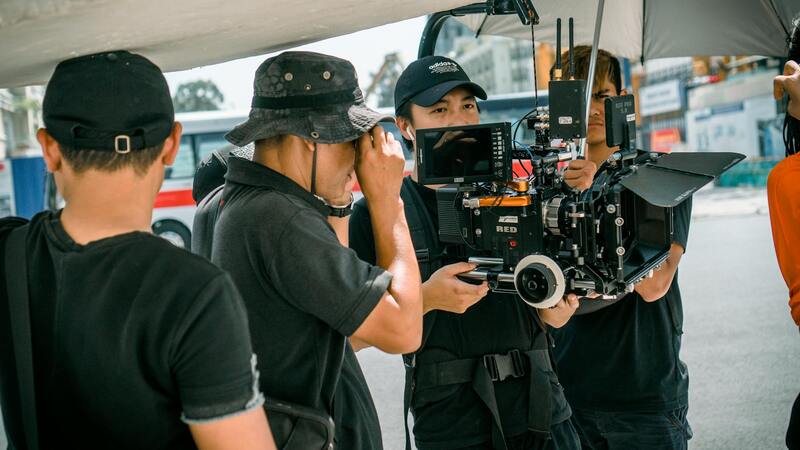
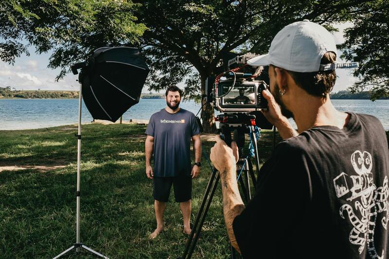
Executing professional realtor drone photography requires adherence to established best practices to ensure captivating, high-quality images that effectively showcase Miami properties. First, selecting optimal weather conditions is crucial. Clear days with minimal wind reduce the risk of shaky footage and ensure sharp, stable aerial shots. Scheduling shoots during golden hours—early morning or late afternoon—also provides natural lighting that enhances property features and creates inviting visuals.
Pre-flight planning is essential. This involves scouting the property to identify the best angles and vantage points, considering surrounding landscapes, nearby amenities, and potential obstructions. Detailed flight path planning helps avoid shaded areas or unwanted inclusion of neighboring properties, maintaining focus on the property itself.
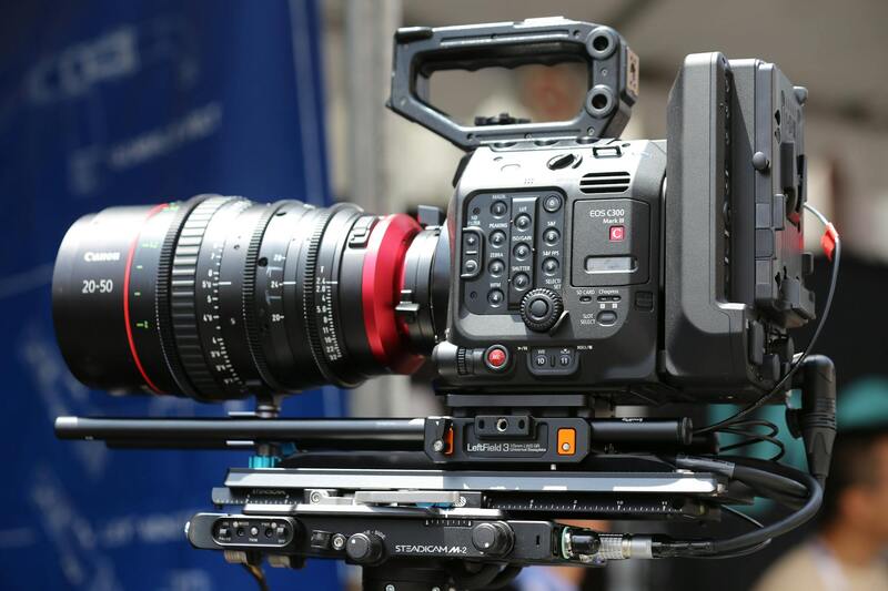
Use high-resolution cameras with stabilized gimbal systems to capture crisp images and videos. Drones equipped with wide-angle lenses are particularly effective in showcasing expansive property grounds and impressive architectural features. Maintaining a consistent altitude and angle throughout the shoot creates a cohesive visual flow across images.
Post-flight, it’s vital to review footage promptly to identify any necessary retakes. Skillful editing can enhance colors, adjust brightness, and stabilize footage, resulting in polished marketing materials. These practices collectively contribute to compelling visual content that aligns with professional standards, effectively engaging prospective buyers.
Integrating Drone Photography into Property Marketing
An effective approach to property marketing leverages the compelling visuals captured through drone photography. High-quality aerial images and videos serve as primary tools for online listings, social media, and virtual tours. Incorporating drone shots at various stages of the property showcase maximizes visual appeal, highlighting both exterior features and surrounding neighborhood highlights.
- Embed aerial imagery within online property listings to create immersive experiences for potential buyers.
- Use consistent branding elements alongside drone visuals to build recognition and trust.
- Enhance virtual tours with smoothly integrated drone footage, providing comprehensive perspectives of the property and its environment.
- Share aerial videos on social media channels to increase reach and engagement among targeted audiences.
By integrating high-quality drone visuals into marketing strategies, real estate professionals can differentiate their listings, attract more inquiries, and ultimately accelerate property sales. Consistent use of professional imagery underscores a commitment to quality and innovation in the Miami real estate market.
Cost Considerations and Hiring a Drone Photographer
Pricing for realtor drone photography varies based on factors such as property size, location, and the scope of the project. Hiring a licensed drone photographer with proven experience ensures that the visual content produced aligns with industry standards and meets client expectations. While investing in professional services may involve higher upfront costs, the benefits of top-tier imagery often translate into faster sales and higher property valuations.
When selecting a drone photographer, review portfolios to assess their technical skills and artistic vision. Confirm that they adhere to official standards and utilize appropriate equipment to deliver high-resolution images and smooth videography. Additionally, clear communication regarding project requirements, deadlines, and deliverables helps facilitate a smooth collaboration.
Opting for package deals that combine multiple shoots or ongoing marketing support can offer cost efficiencies. Ultimately, the investment in professional drone services enhances the credibility and appeal of the listings, ensuring the property stands out in a competitive market.
Understanding Realtor Drone Photography
Realtor drone photography involves using unmanned aerial vehicles (UAVs) to capture high-quality images and videos of real estate properties from a bird's-eye perspective. This innovative approach allows for showcasing properties with comprehensive aerial views, highlighting land features, surrounding neighborhoods, and landscaping details that traditional photography cannot effectively capture. By employing specialized drone technology, real estate professionals can create visually compelling marketing materials that attract potential buyers and facilitate faster transactions.
The Technical Aspects of Drone Photography
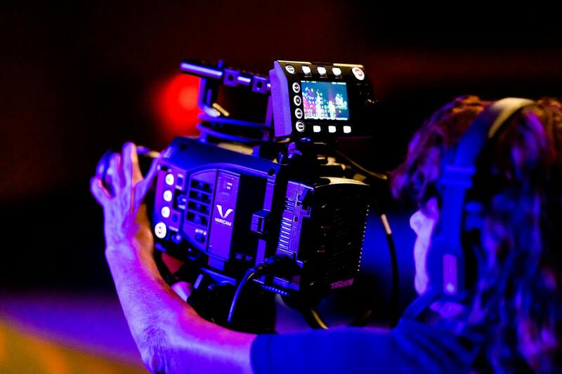
Effective realtor drone photography relies on advanced equipment that offers stability, precision, and high-resolution imaging capabilities. Drones are equipped with high-definition cameras, gimbals for stabilization, and GPS systems for accurate positioning. Skilled operators plan flight paths meticulously, considering optimal angles and altitudes to ensure images are both aesthetic and informative. This technical proficiency results in captivating visuals that accurately represent property features while adhering to safety and operational standards.
Additionally, post-flight editing plays a crucial role in enhancing aerial imagery. Techniques such as color correction, contrast enhancement, and panoramic stitching help produce polished content that elevates a property’s presentation. This combination of cutting-edge drone hardware, strategic flight planning, and skilled editing culminates in images and videos that inspire confidence and interest among prospective buyers.
The Impact of Aerial Photography on Listing Effectiveness
High-quality aerial imagery significantly improves the visibility and appeal of real estate listings. It provides a comprehensive view of the property and its surroundings, fostering a better understanding of spatial relationships and neighborhood amenities. For buyers, this perspective can reveal proximity to schools, parks, transportation hubs, and community features, thereby making listings more compelling.
Moreover, incorporating drone-captured visuals into online listings enhances engagement metrics such as click-through rates and time spent viewing the property. These indicators are crucial for real estate professionals seeking to attract serious buyers and facilitate quicker sales. Furthermore, professional drone photography helps differentiate listings in a competitive Miami market, where visual appeal can determine buyer interest and ultimately influence market value.
Choosing the Right Drone Equipment for Realtor Photography
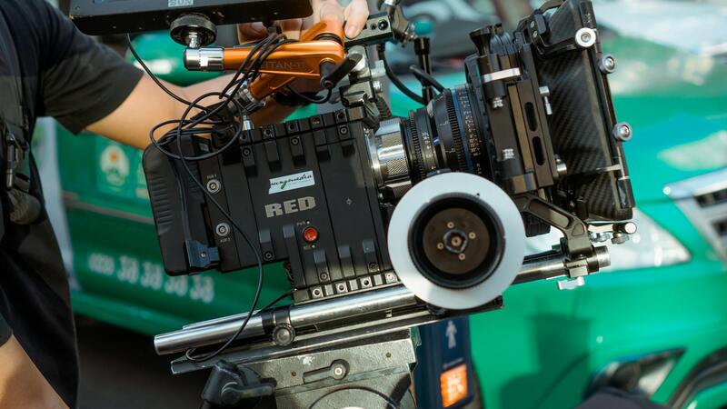
When selecting drone equipment for real estate photography in Miami, it is essential to prioritize tools that can deliver high-resolution imagery with stable flight capabilities. High-quality cameras with 20MP sensors and 4K video recording capabilities are typically preferred, as they capture crisp, detailed visuals that effectively showcase property features and surrounding landscapes. Additionally, gimbal stabilization technology ensures smooth footage, minimizing vibrations and jitters that can detract from professionalism.
Another crucial aspect is the drone's autonomous flight features, including GPS-assisted navigation and intelligent flight modes. These functionalities enable precise positioning, automated flight paths, and repeatable captures essential for creating consistent marketing visuals. Features such as obstacle avoidance sensors are equally valuable, especially in complex or confined shooting environments like dense urban landscapes or coastal areas in Miami.
Battery life is also a key consideration. Drones equipped with extended battery capacities allow for longer flight times, reducing the need for multiple landings and takeoffs during a single session. This efficiency is particularly beneficial when capturing large estates or multiple vantage points around a property.
Best Practices for Shooting Realtor Drone Photos
Effective drone photography for real estate listings requires strategic planning and adherence to best practices. Start with a comprehensive shot list that includes key angles, such as front elevation, backyard, landscaping details, and aerial views of neighboring amenities. Ensuring proper lighting—preferably during the golden hours near sunrise or sunset—enhances the visual appeal of images by providing warm, natural light and softer shadows.
Pre-flight preparations are equally important. These include reviewing weather conditions to avoid wind or rain interference, verifying the drone’s calibration, and establishing clear flight paths that avoid obstacles and respect privacy boundaries. Conducting a preliminary site assessment helps identify potential hazards and optimal shooting angles.
During flight, maintaining steady control and consistent altitude ensures uniformity across shots. Utilizing intelligent flight modes like orbit, waypoint, or panorama allows for creative compositions that highlight the property’s size, layout, and unique features. Post-flight, ensuring that images are properly edited—adjusting color balance, sharpness, and contrast—further enhances their impact in listings.
Choosing the Right Drone Equipment for Realtor Photography
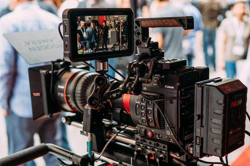
Selecting appropriate drone equipment is essential to capturing high-quality realtor drone photography that effectively showcases a property's best features. Professionals in the real estate industry typically rely on drones equipped with high-resolution cameras capable of capturing detailed aerial images and videos. These cameras should support 4K or higher resolutions to ensure crisp, vibrant visuals suitable for both print and digital listings.
Moreover, the drone's stabilization system plays a critical role in delivering smooth footage, especially when capturing dynamic shots or video tours. Gimbal stabilization ensures that images remain clear and steady, minimizing motion blur and camera shake.
Battery life is another important factor; longer flight times allow for comprehensive coverage of larger properties without frequent recharging. This ensures efficient use of time and resources during shoots.
Advanced drone features such as GPS positioning, automated flight modes, and obstacle avoidance enhance safety and precision during shoots. GPS capabilities allow for accurate positioning and repeatability of shots, while obstacle avoidance systems prevent collisions with nearby objects or structures, reducing risks and potential equipment damage.
When considering equipment, it’s vital to match the drone’s capabilities with the specific requirements of real estate projects. For example, homes on expansive lots or properties with complex access points may benefit from drones capable of longer range and higher stability in varying environmental conditions.
Types of Cameras Ideal for Realtor Drone Photography
- Mirrorless or DSLR cameras mounted on professional-grade drone gimbals
- Compact, high-resolution cameras with wide-angle lenses for panoramic shots
- Thermal cameras for specialized property inspections (less common for standard listings)
Investing in versatile equipment ensures that every property can be presented in the most compelling way, leveraging the unique perspective that only aerial photography can provide.
Enhancing Property Listings with Aerial Footage Integration
Incorporating drone-captured images into an extensive property marketing strategy maximizes the visual appeal and provides potential buyers with a comprehensive view of the estate's entire layout. High-resolution aerial photographs and videos can be seamlessly integrated across various digital platforms, including MLS listings, real estate websites, and social media channels, creating a cohesive and immersive experience for viewers. This multi-platform approach not only attracts a broader audience but also elevates the property's perceived value by highlighting its unique selling points such as expansive outdoor spaces, beautiful landscaping, or proximity to desirable amenities.
Effective use of drone imagery in marketing campaigns involves selecting the most compelling visuals that tell a story about the property. This could include sweeping drone shots capturing the entire estate, close-up views of key features, or video walkthroughs that guide viewers through the property with dynamic footage. When incorporated thoughtfully, aerial photography acts as a powerful differentiator in a competitive housing market, capturing buyer interest and facilitating quicker sales.
Maximizing Impact Through Professional Presentation
Once drone footage is acquired, professional editing plays a crucial role in enhancing clarity, color balance, and overall presentation quality. Editing can also include adding animated text or overlays with property details, creating a polished promotional package suitable for websites, virtual tours, and social media advertising. Furthermore, consistency in branding and messaging across all visual content reinforces credibility and builds trust with prospective clients.
Training and Certification for Effective Drone Operation
Proper training for drone operators ensures that the footage captured adheres to industry standards in safety, quality, and operational efficiency. Certified pilots are adept at maneuvering drones to achieve optimal framing and lighting conditions, while also understanding how to efficiently cover large or complex properties. Investing in skilled professionals guarantees that every aerial shot aligns with the intended marketing strategy and upholds the high standards expected by clients and audiences alike.
Utilizing High-Quality Post-Production Techniques
Post-production processes are vital in transforming raw drone footage into visually compelling material. Professional editing software allows for color correction, stabilization, and the addition of cinematic effects that enhance visual storytelling. Additionally, techniques such as HDR imaging can improve details in shadowed or illuminated areas, providing a balanced and true-to-life depiction of the property. Well-crafted videos and images convey a sense of professionalism and dedication, further enticing potential buyers and investors.
Future Possibilities and Technological Advancements
As drone technology continues to evolve, so will the methods of integrating aerial imagery within real estate marketing. Developments such as 8K resolution cameras, AI-powered editing tools, and autonomous flight paths will enable even more precise and stunning visuals. Moreover, the integration of virtual reality (VR) and 3D mapping with drone footage offers innovative avenues for remote property exploration, enhancing buyer experience and expanding market reach in the Miami area and beyond.